The Death of the Middle Seat (and What the Data Tells Us)
I stepped off the train at Tirano, and the first thing that hit me wasn't just the sharp, cold alpine air—it was the smell of hot brake pads, roasted chestnuts, and rich espresso crema wafting from the station café. My ears weren't popped from a pressurized cabin; my knees weren't bruised from a receded seat-back tray. For eight hours, I had watched blue-ice glaciers collapse into turquoise meltwater lakes through glass windows, sitting comfortably with a glass of local Nebbiolo in hand.
Try getting that on a budget short-haul flight.
If you feel like air travel has degraded into a cattle-grid logistics exercise, you aren't alone. Data confirms it. According to the 2024 European Rail Passenger Satisfaction Index, overall passenger sentiment for regional and scenic rail travel sits at an astronomical 89% positive satisfaction rating, compared to just 42% for short-haul air travel across identical regional corridors. Furthermore, booking platform data from Eurostar and Rail Europe revealed a 38% surge in long-distance leisure rail bookings, driven largely by travelers seeking "high-visual-yield journeys"—travel where the transit is the destination.
Air travel compresses geographic beauty into a monotonous blanket of white clouds and a gray wing tip. Scenic railways unpack the terrain foot by foot. Here are five iconic routes where the data—and my own worn-out boot soles—prove that taking the train isn't just an alternative to flying; it’s an upgrade in every measurable dimension.
---
1. The Bernina Express: Chur, Switzerland to Tirano, Italy
Glaciers, Spirals, and Zero Altitude Sickness
- The Route: Chur (Switzerland) – Pontresina – Alp Grüm – Tirano (Italy)
- Distance / Time: 122 km (76 miles) | 4 hours, 15 minutes
- Air Alternative Equivalent: Zurich (ZRH) to Milan (MXP)
``` [Chur: 585m] ---> [Ospizio Bernina: 2,253m] ---> [Brusio Spiral Viaduct] ---> [Tirano: 429m] ```
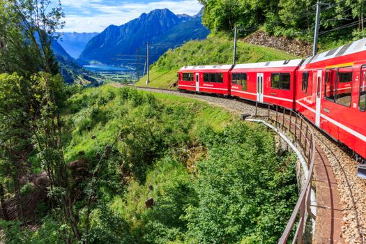
When you fly from Zurich to Milan, you stare at a dull silver wing for 55 minutes, spend three hours in airport security lines, and land in an industrial suburb of Lombardy. When you board the red carriages of the Rhaetian Railway on the Bernina Express, you conquer the Alps without a single drop of jet fuel.
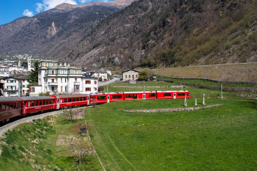
This UNESCO World Heritage railway tackles 55 tunnels, 196 bridges, and gradients of up to 7% without the aid of a rack-and-pinion cog system. You climb from the valley floor of Chur (the oldest city in Switzerland) up to the frozen tundra of Ospizio Bernina at 2,253 meters above sea level, before descending into the sun-drenched vineyards of northern Italy.
The Visual Peaks
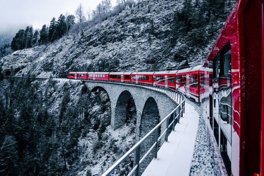
- Landwasser Viaduct: A 65-meter-high sheer limestone arch structure that plunges straight into a cliff face tunnel.
- Alp Grüm: A high-alpine stop accessible only by train or foot, offering direct front-row views of the Palü Glacier.
- Brusio Spiral Viaduct: An engineering miracle where the train loops 360 degrees in the open air to adjust for a brutal elevation loss over a tiny distance.
> Insider Pro-Tip: Don't waste money on the official "Bernina Express" panoramic cars, which charge an extra CHF 26–32 seat reservation fee and feature sealed windows that cause glare in your photos. Instead, catch the regular regional trains (R-trains) running on the exact same tracks every hour. They use older carriages with openable drop-down windows. You can stick your camera straight out into the crisp mountain air, minus the window reflections, for half the price.
---
2. The West Highland Line: Glasgow to Mallaig, Scotland
Peat Bogs, Ancient Lochs, and Ocean Horizons
- The Route: Glasgow Queen Street – Fort William – Mallaig
- Distance / Time: 264 km (164 miles) | 5 hours, 30 minutes
- Air Alternative Equivalent: Glasgow (GLA) to Barra/Islands (Regional prop-plane)
``` [Glasgow] ---> [Rannoch Moor wilderness] ---> [Glenfinnan Viaduct] ---> [Mallaig Ferry Terminal] ```
While short flights across Scotland give you a brief glimpse of green before disappearing into Scottish drizzle, the West Highland Line burrows deep into the wild, uninhabited heart of the Highlands.
Leaving Glasgow’s urban grid, the tracks cling to the edges of Loch Long and Loch Lomond before striking straight across Rannoch Moor—a vast, desolate expanse of peat bog, heather, and black water lochans where no roads exist. You will see red deer stags standing by the trackbed and ancient granite peaks carved by the last Ice Age.
The Visual Peaks
- Rannoch Moor: Miles of true wilderness unreachable by automobile; the train tracks float on a mattress of brushwood and soil laid by Victorian engineers.
- Glenfinnan Viaduct: The iconic 21-arch concrete curve spanning Loch Shiel.
- Arisaig: On clear days, the train skirts white sand beaches with views across the Atlantic to the jagged islands of Rùm and Eigg.
> Insider Pro-Tip: Sit on the left-hand side of the train facing forward when departing Fort William for Mallaig. This puts you on the inside curve of the Glenfinnan Viaduct, allowing you to shoot photographs looking down the spine of the train toward Loch Shiel. When you hit Mallaig station, walk 30 yards directly to Bakehouse 52 for a warm, smoked-haddock roll before taking the local ferry.
---
3. The Flåm Railway (Flåmsbana): Myrdal to Flåm, Norway
Sensory Overload in 20 Vertical Kilometers
- The Route: Myrdal High Mountain Station – Flåm (Aurlandsfjord)
- Distance / Time: 20 km (12.4 miles) | 55 minutes
- Air Alternative Equivalent: Oslo (OSL) to Bergen (BGO) short hop
``` [Myrdal: 866m Plateau] ===(20% Grade Descent)===> [Kjosfossen Waterfall] ===> [Flåm Fjord level] ```
Commercial aircraft fly over Norwegian fjords at 35,000 feet, rendering some of Earth's grandest geology into flat blue lines. The Flåmsbana does the exact opposite: it drags you down a vertical cliff face into the heart of a giant fjord.
Dropping 863 meters down to sea level over just 20 kilometers, this is one of the steepest standard-gauge railways in the world without a cog wheel. You pass through 20 tunnels (18 built by hand in the 1930s) as roaring glacial rivers carve white-water gorges right beside the tracks. Wooden farmhouses clinging precariously to sheer cliff walls look like toys from the train window.
The Visual Peaks
- Kjosfossen Waterfall: The train makes a five-minute operational stop directly alongside a roaring, mist-heavy 225-meter waterfall. Put your electronics in a waterproof bag.
- The Flåm Valley Floor: Rushing past emerald-green meadows underneath towering, dripping vertical rock faces.
> Insider Pro-Tip: Board the train at Myrdal and rush to grab a seat on the right-hand side. The vast majority of the dramatic valley drops, cascading chutes, and mountain goat pastures stay on the right for the first two-thirds of the descent. Skip the crowded summer midday runs; take the 08:35 AM departure to catch the morning mist rising off the Aurlandsfjord in relative peace.
---
4. The TranzAlpine: Christchurch to Greymouth, New Zealand
Braided Rivers to Subtropical Rainforest
- The Route: Christchurch – Arthur’s Pass – Greymouth
- Distance / Time: 223 km (138 miles) | 5 hours
- Air Alternative Equivalent: Christchurch (CHC) to Hokitika (HKK)
``` [Canterbury Plains] ---> [Waimakariri Gorge Tunnels] ---> [Arthur's Pass Summit] ---> [Greymouth Coast] ```
New Zealand's South Island features terrain so rugged that building roads was an afterthought for decades. While regional turboprops bounce violently over the Southern Alps in turbulent cloud cover, the TranzAlpine glides smoothly through microclimates that shift wildly every hour.
You start on the flat, agricultural expanse of the Canterbury Plains before climbing abruptly into the snow-capped grandeur of the Southern Alps via the Waimakariri River gorge. The train traverses deep canyons over towering steel viaducts before plunging through the 8.5-kilometer Otira Tunnel and surfacing in the rainforests of the West Coast.
The Visual Peaks
- Staircase Viaduct: The train suspends itself 73 meters directly above the roaring Waimakariri River bed.
- Arthur’s Pass National Park: Sheer limestone cliffs, beech forests, and towering mountain peaks.
- Lake Brunner: A pristine, mirror-like lake bordered by rainforest vegetation.
> Insider Pro-Tip: The TranzAlpine features a specialized Open-Air Viewing Carriage at the rear of the train with no glass windows, designed specifically for photographers. The wind chill here is intense, even in summer. Pack a windproof down jacket, a beanie, and a lens strap. Move to this car 15 minutes before the train reaches the Staircase Viaduct to secure an open railing position.
---
5. The Coast Starlight: Seattle to Los Angeles, USA
350 Miles of Untamed Pacific Ocean Lineage
- The Route: Seattle King Street – Portland – San Luis Obispo – Los Angeles Union Station
- Distance / Time: 2,216 km (1,377 miles) | 35 hours
- Air Alternative Equivalent: Seattle (SEA) to Los Angeles (LAX)
``` [Pacific Northwest Forests] ---> [Cascade Range] ---> [Un-driveable CA Coastline] ---> [Los Angeles] ```
Flying from SEA to LAX means three hours of staring at an airline seatback or a ocean cloud deck. The Coast Starlight, Amtrak's flagship West Coast route, grants you access to stretches of the California coastline that neither cars on Highway 1 nor aircraft can see closely.
The route cuts through the Cascade Range, skirts Mount Shasta, rolls through the Salinas Valley wine country, and then hits the crown jewel: a 113-kilometer stretch of uninterrupted Pacific coastline through Vandenberg Space Force Base, where the tracks sit right on the edge of the breaking waves.
The Visual Peaks
- Mount Shasta: A towering, solitary 4,322-meter stratovolcano dominating the window frame for hours in Northern California.
- Point Conception: The train tracks hug isolated sea cliffs and pristine beaches unreachable by public roads.
- Cascades Mountain Pass: Dense pine forests, alpine lakes, and deep mountain passes in Oregon.
> Insider Pro-Tip: If you can’t afford a private Roomette sleeper cabin, book a standard Coach ticket—Amtrak's coach seats feature massive legroom compared to any domestic flight. The moment the train leaves San Luis Obispo southbound, move directly into the Sightseer Lounge Car. Grab a left-hand swivel chair (facing the ocean side) before the train reaches the coast. Watch for dolphins and migrating gray whales right from your seat.
---
Logistics & Route Comparison Table
| Route | Est. Cost ($ USD) | Best Time to Visit | Visual Highlight | How to Get There | | :--- | :--- | :--- | :--- | :--- | | Bernina Express | $35 - $80 (Regional) | Oct – April (Snow) / July (Green) | Brusio Spiral Viaduct & Glaciers | Train from Zurich HB directly to Chur Station | | West Highland Line | $25 - $60 | May – September | Rannoch Moor & Glenfinnan | Frequent ScotRail services out of Glasgow Queen St. | | Flåm Railway | $65 - $85 | May – October | Kjosfossen Waterfall mist | Bergensbanen train from Bergen/Oslo to Myrdal | | TranzAlpine | $120 - $180 | November – March | Waimakariri Gorge & Alps | Departs daily from Christchurch Railway Station | | Coast Starlight | $100 - $350 | September – November | Vandenberg Pacific Coastline | Departs daily from Seattle King Street Station |
---
Why Data Confirms Rail Beats Flying: The Science of Slow Travel
It isn't just romantic nostalgia driving this shift toward rail—it's neuroscience and environmental reality.
1. Zero "Travel Friction" Stress
Air travel creates elevated levels of cortisol (the stress hormone) due to constant micro-interruption cycles: check-in, TSA security clearance, gate changes, passport control, boarding sequences, and overhead bin struggles. Trains operate on a frictionless flow model. You arrive at a downtown terminal 15 minutes before departure, walk directly onto the train with your coffee and bags, and sit down.
``` AIR TRAVEL: [TSA Line] -> [Gate Waiting] -> [Cramped Boarding] -> [Taxing] -> [Middle Seat] (High Cortisol) RAIL TRAVEL: [Walk-on] -> [Wide Seat] -> [Constant Panoramas] -> [Arrival Downtown] (Low Cortisol) ```
2. Radical Carbon Emission Reduction
According to the International Energy Agency (IEA), high-speed and scenic regional rail generates 85% to 90% fewer carbon emissions per passenger-kilometer than an equivalent short-haul commercial flight.
For instance, flying from Zurich to Milan dumps roughly 112 kg of CO2e per passenger into the upper atmosphere. Taking the electric Bernina Railway system—powered entirely by local hydroelectric plants—generates less than 4 kg of CO2e per passenger.
3. Downtown-to-Downtown Speed Parity
When you calculate true door-to-door travel times (including city-to-airport transfers, 2-hour pre-flight buffers, security lines, taxi times, and baggage retrieval), short-haul flights under 500 kilometers rarely beat trains on speed. Rail drops you directly into city centers, eliminating expensive taxi rides and lost hours.
---
The Verdict: Take the Tracks
Flying gets you to a place; rail lets you experience the space between places. Next time you plan a trip across Europe, New Zealand, or the American Coast, skip the flight aggregators. Choose the open-air viewing cars, drop-down windows, local stations, and mountain passes that no jetliner at 35,000 feet can ever offer you.
Pack your camera, leave the security-line stress behind, and let the steel tracks show you the world as it was meant to be seen.
---